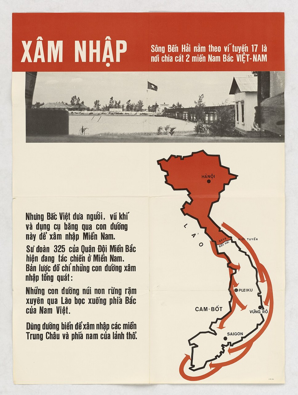
Xâm nhập (Infiltrate) is a 1965 poster from the JUSPAO printing section for the South Vietnamese government. It pairs a photograph of the Ben Hai river bridge at the 17th parallel with a map of Vietnam, its northern half in red, and red arrows running south through Laos and by sea (NAID 26326296).
A bridge and a map
The poster has two pictures. The first is a photograph of the bridge over the Ben Hai river at the 17th parallel, with a flag flying on the northern bank. The second is a map of Vietnam with the northern half filled in red. Red arrows run south through Laos and by sea, ending at named places.
XÂM NHẬP
Sông Bến Hải nằm theo vĩ tuyến 17 là nơi chia cắt 2 miền Nam Bắc VIỆT-NAM
Nhưng Bắc Việt đưa người, vũ khí và dụng cụ băng qua con đường này để xâm nhập Miền Nam.
Sư đoàn 325 của Quân Đội Miền Bắc hiện đang tác chiến ở Miền Nam. Bản lược đồ chỉ những con đường xâm nhập tổng quát:
[...]
Map labels: HÀNỘI; LÀO; Sông Bến Hải; GIỚI TUYẾN; PLEIKU; CAM-BỐT; VŨNG RÔ; SAIGON
The archive gives the content in English: the text states that North Vietnam sends men and weapons across this line into the South and that the North's 325th Division is fighting in the South.
The record
FRAME credits the "Joint U.S. Public Affairs Office (JUSPAO) printing section, for the South Vietnamese government," and dates the poster 1965. The image comes from the National Archives through Wikimedia Commons and the Digital Public Library of America, retrieved by the archive on 2 October 2026. The rights line records it as public domain. The audience is coded as a foreign public, the purpose as persuading or winning support, and the source category as "Source blurred: contractors, cutouts, buried disclosure."
Reading it
FRAME tags one technique, card stacking. The archive's reading is that the map shows routes in one direction only and that the sheet cites no source for its claims. A reader is given a unit number, a river and a set of arrows, and asked to take the rest on trust.
A map is a persuasive form because it looks like a measurement. This one draws routes as arrows. It does not say how many men came south, when, or how the information was gathered. The record does not test whether the claims were true. What it shows is a sheet that asks for belief without offering a way to check.
The same 17th parallel was the dividing line on the 1954 Go South to Avoid Communism map, which drew burning houses in the north and rice farming in the south. The U.S. Information Agency made the infiltration case to foreign readers in Aggression from the North, distributed in Manila in 1965 with figures attached. The Vietnam War messaging hub covers this series and the Tonkin address, a case where the hub finds an official claim firmer than its evidence.
Sources
- FRAME object record, Xâm nhập (Infiltrate), 1965. Joint U.S. Public Affairs Office (JUSPAO) printing section, for the South Vietnamese government.
- U.S. National Archives, Records of the U.S. Information Agency (RG 306), NAID 26326296, via Wikimedia Commons (DPLA), retrieved by the archive 2 October 2026. Rights as recorded: public domain (U.S. government work; Commons PD-US, PD-South VietnamGov; NARA NoC-US).